Larnaca port (CYLNC) is the second, in magnitude, port of our country and it is situated in the southeastern part of Cyprus.
Until 1973 the port of Larnaca was operating as a roadstead with inadequate port facilities which the town offered in the area where today lays the Marina i.e. at the town center. With the exception of the oil products, the port had served up to that time very little trade traffic and its storage space was quite small and unsuitable.
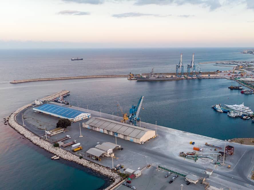
In its present form, Larnaca port is situated approximately 2 km from the town center and on the landside is surrounded by residential units. On the north side there are oil product installations and at the south side it borders with Larnaca marina.
An advantage for the port is the fact that at a distance of 6 kilometers lays Larnaca International Airport.
The new Larnaca port was completed in June 1973 and was initially intended to share with Famagusta port its inland area and supplement the latter. It commenced operation at the end of 1973.
Today it is a multipurpose port having an area of 445.000 sq. meters and serves all kinds of loads from unpacked (animal fodder, grain, gypsum), conventional (lumber, iron, fertilizers, automobiles) as well as oil products.


| NAME OF PORT | LARNACA |
| General Information | |
| Position | South Coast of the Island |
| Function | Multipurpose port |
| Topography | Southern Coast-Central Part |
| Port limits | That part of the coastline and the territorial waters of Cyprus, contained within a line drawn 089º to the high seas from Livadhia Church Belfry and a line drawn 089º from the Mosque (Hala Sultan Tekke) on Admiralty Chart No. 851 of the 8 th August 1941. |
| Approach and entry | The port is dredged to 12m and the approach channel is dredged to 13m with a minimum width of 160m. Maximum draught allowed 11.4m. The height of the quay is 2.3m above sea level. |
| Port Authority | Cyprus Ports Authority |
| Limiting Conditions | |
| Controlling depth | 11.40m |
| Deepest and longer berth | 12.0m , 340m South Quay. |
| Mean tidal levels | 0.30m |
| Abnormal levels | 0.60m |
| Density of water | 1025 |
| Maximum size of vessel handled | 270m |
| Local weather | Fair, Prevailing winds summer SW 4-5 |
| Sea state | Slight to moderate |
| Arrival Information | |
| Port operations | Multipurpose (including small quantities of fuel oil) |
| Vessel Traffic Service | |
| Port radio | VHF CH 14-16 |
| Notice of ETA | 24 hrs prior to arrival |
| Outer anchorages | Cargo and passenger vessels should anchor S of a line drawn 090º from the head of the S breakwater of the main harbour and North of a line drawn 090º from Marina South Breakwater in position: 34º 55.2N 33º 38.6E |
| Pilots | Available at any time |
| Tugs | MARION 3500 HP 35T Bollard Pull ONISILLOS 1320 12 ZENON 620 3.5 |
| Local knowledge | -- |
| Regulations concerning entry | Always after Harbour Master's approval. |
| Quarantine | Pratique Granted before or after berthing |
| Notice of medical requirements | To be sent 3 hrs prior to arrival |
| Harbour | |
| General layout | The harbour is formed and protected by two curved breakwaters and dredged to 12m. It offers a quay length of 666m with depth of 10-12m. |
| Seaplane harbour/area | Turning circle 300m. |
| Hazards | - |
| Measured distance | - |
| Degaussing range | - |
| Traffic signals | - |
| Storm signals | - |
| Natural conditions | Usually Fair |
| Principal marks | - |
| Directions for entering harbour | From a position approx. 0.5nm ENE of the harbour entrance , the line of bearing 242º of the harbour entrance leads WSW passing (with positions given from the head of S breakwater): Close SSE of Fairway lightbuoy 0.3nm NE, which marks the entrance to the approach channel thence; NNW of the head of S breakwater and SSE of a buoy 0.075nm NNW, which marks the NNW side of the channel, thence SSE of the head of N breakwater. |
| Approaches | |
| Entrance channel | The approach channel is dredged to 13m with a minimum width of 160m. Maximum draught allowed 11.4m. |
| Direction for leaving harbour | In accordance with pilots instructions. |
| Basins and berths | |
| Basins | Turning circle 300m |
| Anchorage and moorings | - |
| Alongside berths | N.Q. 326m 10m depth, S.Q.340m 12m depth |
| Port services | |
| Diplomatic representation | Mainly in Nicosia-Approx. 50km from Larnaca |
| Repairs | Minor repairs can be performed. |
| Other facilities | Bunkering, garbage collection, oil waste |
| Supplies | Stores, fresh water, provisions. |
| Communications | Taxi & bus service available at port gate. |
| Harbour regulations | IMO regulations applicable |
| Small craft facilities | Not available |

