| NAME OF PORT | LEMESOS (LIMASSOL) |
| General Information |
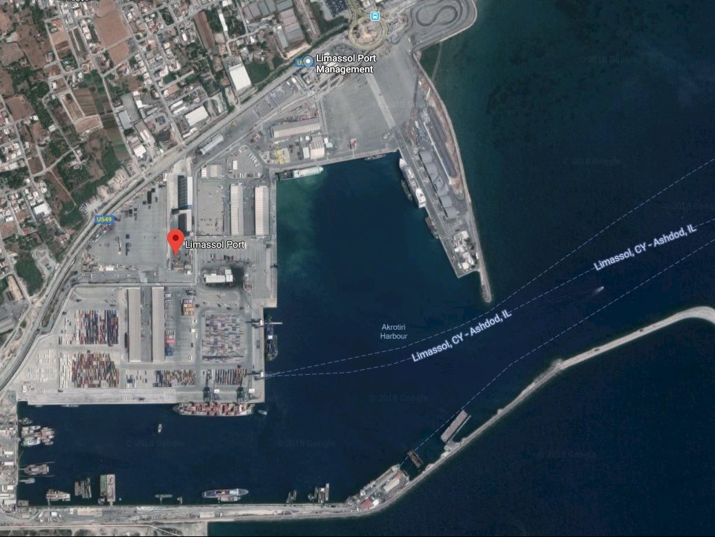
| Position | Is situated on the S coast of Cyprus at the head of the Akrotiri bay, about 5 ½ miles N of Cape Gata in position (34º 39’ N 033º 01’ E) |
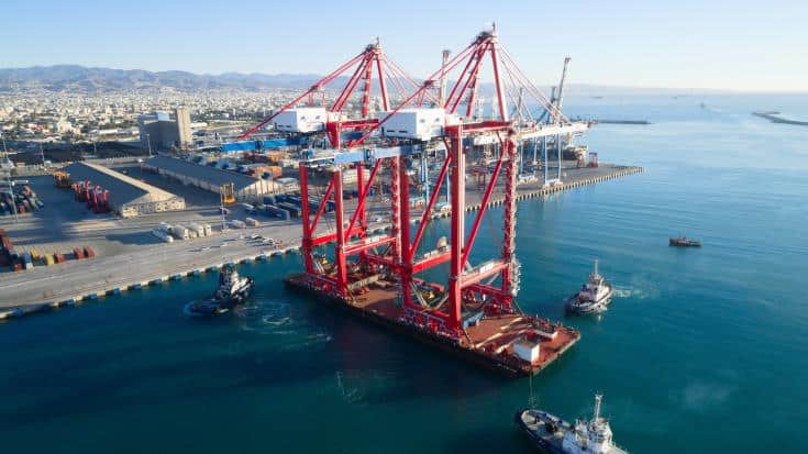
| Function | Multipurpose port and the principal port of Cyprus with modern facilities for handling passengers, containers, Ro-Ro, general cargo vessels and bulk carriers. |
| Topography | Behind the town, the land rises gradually in tree-covered, wedge-shaped hills. |
| Port limits | The part of coast and the territorial waters of Cyprus which is enclosed between line standing from Roman Catholic Cemetery where situated 16,5 cables Northeasterly of Limassol port, fixed red lighthouse, towards open sea and the line standing 108 degrees starting from the point where beach contact the south main breakwater of Limassol new port, towards open sea for distance 7.8 nautical miles and from that point on direction of 136 degrees until latitude 34 degrees North & 30 minutes East. |
| Approach and entry | The port is approached by a channel, dredged to a depth of -17m over a width of 150m. The centerline of the channel is marketed with the alignment 248º of leading lights (metal framework tower with orange diamond top marls), situated at the southwest end of the port. The front line becomes visible only when nearly in line with the rear light. The seaward end of the channel is market by a green fairway buoy. |
| Traffic | During 2010 Limassol port served 3.405 ships with total of 20 million net register tonnage, 3,69 million tons of cargo, 380.278 passengers |
Port Authority
Port Manager | Cyprus Ports Authority
Limassol Port Manager, Limassol New Port, P.O.Box.: 53331,3302 Limassol. |
| Limiting Conditions |
| Controlling depth | The entrance channel of Limassol Port is dredged to a depth of -17 m over a width of 150 m. The basin between the port entrance and the quays has also been dredged to -17 m. Port’s turning circle is 600m. |
| Deepest and longer berth | 16.0 m, 480 m East Quay. |
| Mean tidal levels | Mean spring range about 0.4 m, mean neap range about 0.2 m |
| Abnormal levels | 0.60m |
| Density of water | 1026 g/m3 |
| Maximum size of vessel handled | Up to 15 m draught with no limitations on the vessels length |
| Local weather | The prevailing summer wind is a sea breeze that normally blows in from the W. It gets up about midday, blows between 3 and 6 and dies down at night. Away from the coast the wind tends to be SW but closer in it follows the contours of the coast so that at Larnaca it blows from SSW-S. Gales can blow from all directions, but most frequently blow from S or E. In the summer there is frequently a sea fog in the early morning which can reduce visibility to less than a mile. It is usually dispersed by midday. Port operations may be interrupted but the fog usually clears by 08.30L, 10.00L latest. Southeast desert winds bring dust to the area, but normally is not a problem. |
| Sea state | Slight to moderate |
| Arrival Information |
| Port operations | Multipurpose (excluding Tankers) |
| Vessel Traffic Services | It is operated from Limassol operations centre on a continuous 24-hours basis. It is manned by internationally qualified VTS officers and operated in accordance with IMO resolution A.857 (20). The centre is responsible for the planning and co-ordination of vessels traffic movements and provides information services concerning the arrival, berthing, anchoring and departure of vessels and also information on aids to navigation, navigation generally, visibility, tidal information and safety of vessels and persons for the Port of Limassol. VHF ch 09 |
| Port radio | VHF CH 10-16 |
| Notice of ETA | 24 hrs prior to arrival |
| Outer anchorages | Anchorage may be obtained within the designated anchorage area centred 1 mile east of Limassol lighter basin, as shown on the chart, in depth of 10 m to 70 m. The holding ground is good, and although the anchorage is open S and E, vessels with good anchors and cables do not normally drag during gales. From October to April, when NE gales occur, it is usual to anchor in a depth of about 22 m.
During the summer the prevailing W winds sometimes reach gale force in the afternoon, making boat work uncomfortable. For this reason it is advisable for small vessels to anchor to the SW.
Anchoring and fishing are prohibited within the approach channel, as shown on the chart. |
| Marine farms | A marine farm, marked by four light-buoys (cardinal), is positioned about 9 cables SE from the head of Main Breakwater. A second farm, closer inshore, is positioned about 2½ cables SE from the elbow of Main Breakwater. |
| Pilots | Pilotage is compulsory and available 24 hours. The pilot boards 1 mile E of the head of Main Breakwater, as shown on the chart. |
| Tugs | Three tugs are available, having the one 1300hp capacity and the other two 3500hp (35T Bollard Pull) and meet vessels outside the port area. |
| Local knowledge | -- |
| Regulations concerning entry | Always after port master's approval. |
| Quarantine | Pratique Granted before or after berthing |
| Notice of medical requirements | Should be sent at least 3 hours before arrival |
| Port |
| General layout | The port comprises Limassol port, on the SW side of the town, and Limassol Lighter Basin 1½ miles NE, which fronts the town.
Limassol Port is an artificial port protected from S by Main Breakwater and from E by Lee Breakwater. The port is quayed on its E, N and W sides and partially quayed in West Basin.
Limassol Lighter Basin is protected by two breakwaters. The E breakwater extends 150 m SSE, thence 180 m SW, forming, respectively, East Quay and South Quay. The W breakwater extends 107 m S, leaving an entrance 46 m wide between the breakwater heads. |
| Seaplane port/area | Turning circle 600m. |
| Hazards | - |
| Measured distance | - |
| Degaussing range | - |
| Traffic signals | - |
| Storm signals | - |
| Natural conditions | Usually Fair |
| Principal marks | Landmarks (positioned from Limassol Lighter Basin entrance (34º 40’.1N 033º 02’.5E): Grain silos (1.7 miles SW), standing near the W quay of Limassol Port. Water tower (elevation 55 m) (6 cables NNW), situated in the central part of the town. Cape Gata Lighthouse (6 miles S). |
| Directions for entering port | From a position about 3 miles SE of the entrance to Limassol port the track leads NNW to the pilot station and the to the beginning of the port entrance leading line: Front light (metal framework tower, orange diamond topmark) (34º 38’.7N 033º 00’.05E). The front light only becomes visible when nearly in line with the rear light.
Rear light (similar structure) (410 m from front light).
The alignment (248º) of these lights leads through the entrance channel, passing (with positions from the head (34º 39’N 033º 02’E) of Main Breakwater):
NNW of a wreck (3 cables ENE), with a depth of 18 m over it, thence:
SSE of a light-buoy (starboard hand) (2 cables N) marking the N side of the channel, and:
NNW of the head of Main Breakwater, from which a light is exhibited, thence:
SSE of the head (4 cables W) of Lee Breakwater, from which a light (metal column, 9 m in height) is exhibited, into the port. |
| Approaches |
| Entrance channel | The approach channel is dredged to 17m with a minimum width of 150m. Maximum draught allowed 14.4 m. |
| Direction for leaving port | In accordance with pilots instructions. |
| Basins and berths |
| Basins | Turning circle 600m |
| Anchorage and moorings | Anchoring and fishing are prohibited within the approach channel, as shown on the chart. ANCHORAGE AREA:- Lat 34º40´,07 N, Long 033º02´,83 E
- Lat 34º40´,55 N, Long 033º03´,50 E
- Lat 34º40´,78 N, Long 033º04´,00 E
- Lat 34º39´,92 N, Long 033º05´,05 E
- Lat 34º39´,61 N, Long 033º03´,25 E
|
| Alongside berths | E.Q. 480m 11m depth, N.Q. 430m 11m depth, W.Q. 450m 11-13m depth, Container Ro-Ro berth 320m 16m depth, Container berth 300m 16m depth, Dolphins berths 1075m 11m depth. |
| Port services |
| Diplomatic representation | Mainly in Nicosia-Approx. 100km from Limassol |
| Repairs | There is a floating dock moored in Limassol port |
| Other facilities | Bunkering, garbage collection, oil waste, First Aid facilities, compass adjustment, fumigation. |
| Supplies | Fuel by small tankers, fresh water at the berths or by barge at the anchorage, provisions, stores. |
| Communications | Taxi & bus service available at port gate. |
| Port regulations | IMO regulations applicable |
| Small craft facilities | Not available |


